
Sign in to access your personal JWT bearer token for authenticated API calls.
DERA API Reference
Integrate environmental risk scoring into your applications. All endpoints are REST-based and require a JWT bearer token.
https://www.dera.earth/DeraAPI
Authentication
Authenticated endpoints use JWT bearer tokens. Obtain a token via /auth/login and include it in the Authorization header of subsequent requests. Tokens expire after 120 minutes.
https://www.dera.earth/DeraAPI
Interactive docs (Swagger UI): dera.earth/DeraAPI/swagger
/auth/register
Create a new account. Returns the created user object.
Request Body (JSON)
| Field | Type | Required | Description |
|---|---|---|---|
email | string | Yes | Valid email address |
username | string | No | 3–50 chars |
password | string | Yes | Min 8 chars |
POST /auth/register
Content-Type: application/json

{ "email": "you@example.com", "password": "yourpassword" }/auth/login
Returns a JWT bearer token. Store it and include it as Authorization: Bearer <token> on authenticated requests.
Request Body (JSON)
| Field | Type | Required | Description |
|---|---|---|---|
email | string | Yes | |
password | string | Yes |
// Response
{ "accessToken": "eyJ...", "token_type": "bearer" }/auth/me
Returns the currently authenticated user's profile. Requires a valid bearer token.
GET /auth/me
Authorization: Bearer eyJ...

// Response
{ "id": 1, "email": "you@example.com", "username": "you",
  "is_active": true, "is_email_verified": false,
"created_at": "2026-01-01T00:00:00", "last_login_at": "2026-05-03T10:00:00" }/DeraApi/active
Returns environmental risk scores for a coordinate pair. The engine analyzes hundreds of land uses within a configurable radius and produces weighted scores across 5 categories. Requires a valid JWT bearer token.
Query Parameters
| Parameter | Type | Required | Description |
|---|---|---|---|
lon |
float | Yes | Longitude in decimal degrees (e.g. 34.7818) |
lat |
float | Yes | Latitude in decimal degrees (e.g. 32.0853) |
CalcType |
string | No | Calculation scope. Default: All |
Example Request
GET https://www.dera.earth/DeraAPI/DeraApi/active
    ?lon=34.7818
    &lat=32.0853
    &CalcType=All
Authorization: Bearer eyJ...
Response
Returns a semicolon-delimited string (not JSON). See Response Format for parsing details.
Noise:6.443;Soil:10;Radiation:10;Air Quality:6.853;Ecology:1.15;Address:Israel, Tel Aviv/api/chat.ashx
AI chat intent detection. Accepts a user message along with the current app context and returns a conversational reply plus a structured intent token that drives UI actions.
Request Body
{
  "message": "What does a score of 6 mean for air quality?",
  "context": {
    "stage": "results_ready",
    "hasLocation": true,
    "hasResults": true,
    "address": "Tel Aviv, Israel",
    "scores": {
      "Noise": 6.443,
      "Soil": 10,
      "Radiation": 10,
      "Air Quality": 6.853,
      "Ecology": 1.15
    }
  }
}
Context Stage Values
| Value | Meaning |
|---|---|
idle | No location selected yet |
location_selected | Location chosen, scores not yet computed |
results_ready | Scores available in context |
Response
{
  "reply": "A score of 6.85 for Air Quality indicates moderate air quality...",
  "intent": "general"
}
Intent Values
| Value | Triggered Action |
|---|---|
general | Informational reply — no UI action |
select_on_map | Prompt user to click a map location |
compute_indices | Trigger score computation for selected location |
generate_report | Open the PDF report generation form |
/api/analyze.ashx
AI narrative analysis of computed scores. Forwards to the PyController service and returns a human-readable interpretation of the environmental assessment.
Request Body
{
  "lastResults": {
    "Noise": 6.443,
    "Soil": 10,
    "Radiation": 10,
    "Air Quality": 6.853,
    "Ecology": 1.15,
    "Address": "Tel Aviv, Israel"
  },
  "context": {
    "address": "Tel Aviv, Israel",
    "lng": 34.7818,
    "lat": 32.0853
  }
}
Response
{
  "text": "This location shows excellent soil and radiation scores (both 10/10), indicating low contamination risk and no significant electromagnetic sources nearby. Air quality scores moderately at 6.85, reflecting urban transport activity in the area. Ecology is the weakest dimension at 1.15, suggesting limited green space in proximity..."
}/byCoordinate?generateBase64Report=true
Generates a full PDF report and returns it as a Base64-encoded string. Accepts all parameters from the Score Analysis endpoint plus the additional parameters below.
Additional Parameters
| Parameter | Required | Description |
|---|---|---|
generateBase64Report |
Yes | Must be set to true |
CustomerName |
Yes | Recipient full name |
Recipients |
Yes | Recipient email address |
ProjectName |
No | Company or project name |
ReportToken |
No | Unique identifier for this report request |
Lang |
No | Report language code. Default: EN_us |
Example Request
GET https://www.dera.earth/ExtractOSMMapProd/ExtractOSMMap/byCoordinate
    ?lon=34.7818
    &lat=32.0853
    &Scale=1000
    &generateBase64Report=true
    &CustomerName=Jane%20Smith
    &Recipients=jane%40example.com
    &ProjectName=Main%20St%20Appraisal
    &Lang=EN_us
Response
Returns a Base64-encoded PDF string.
JVBERi0xLjQKJ... (Base64-encoded PDF)Excel Integration
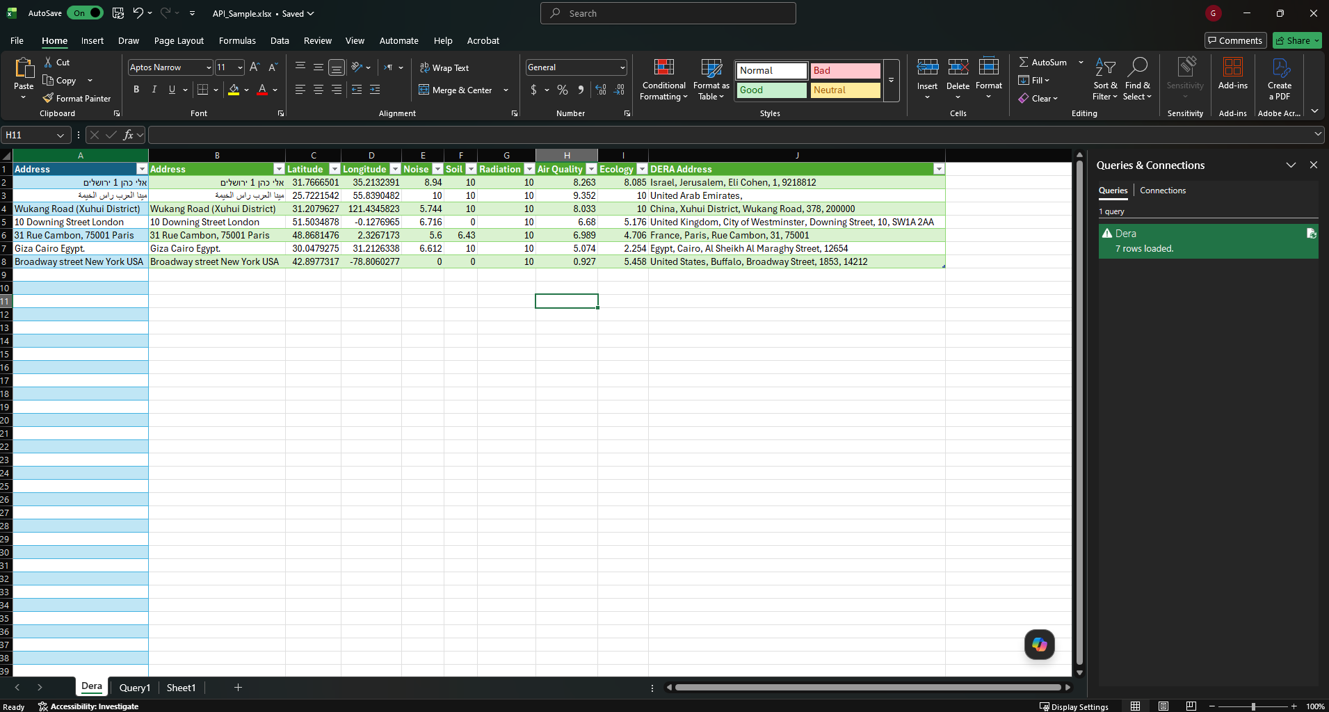
No development resources? Working with a large address list? DERA provides a ready-made Microsoft Excel workbook that connects directly to the API using Power Query — no coding required. Paste your addresses into column A, refresh the query, and all five environmental scores populate automatically across your entire list.
Download Excel Sample (API_Sample.xlsx)Requirements
- Microsoft Excel 2016 or later
- A valid DERA API token — sign in above to get yours
- Macros must be enabled: when prompted by Excel, click Enable Editing, then Enable Content
How to Use
- Open the downloaded
API_Sample.xlsxfile in Microsoft Excel. - When Excel shows the security bar at the top, click Enable Editing and then Enable Content — macros must be active for the query to run.
- Enter or paste your addresses into column A, one address per row.
- Go to the Data tab on the ribbon, then click Queries & Connections. A sidebar will open on the right side.
- In the sidebar you will see the Dera query. Right-click it and select Refresh.
- The API will process each address in your list and fill in the Noise, Soil, Radiation, Air Quality, and Ecology scores alongside the geocoded address string.
Response Format
The Score Analysis endpoint returns a semicolon-delimited string, not JSON. Split on ; then on : to parse:
// JavaScript
const raw = "Noise:6.443;Soil:10;Radiation:10;Air Quality:6.853;Ecology:1.15;Address:Israel, Tel Aviv";
const result = {};
raw.split(";").forEach(part => {
  const colonIdx = part.indexOf(":");
  const key = part.slice(0, colonIdx).trim();
  const val = part.slice(colonIdx + 1).trim();
  result[key] = val;
});
// result → {
//   Noise: "6.443",
//   Soil: "10",
//   Radiation: "10",
//   "Air Quality": "6.853",
//   Ecology: "1.15",
//   Address: "Israel, Tel Aviv"
// }
Note: Address may contain colons (e.g. city names with suffixes), so split only on the first colon per segment.
Score Scale
10 = best (lowest environmental risk). 0 = worst.
The overall DERA Index is a weighted average of all five category scores. Air Quality and Noise each carry double weight (×2), while Soil, Radiation, and Ecology carry single weight (×1):
Overall = (AirQuality×2 + Noise×2 + Soil×1 + Radiation×1 + Ecology×1) / 7Score Categories
Every response includes the following fields:
| Response Field | Category | Weight | Description |
|---|---|---|---|
Air Quality |
Air Quality | ×2 | Industrial and transport emission sources weighted by proximity |
Noise |
Noise | ×2 | Hundreds of land uses scored by noise emission potential |
Soil |
Soil Contamination | ×1 | Industrial activity analyzed for soil and groundwater contamination risk |
Radiation |
Electromagnetic Radiation | ×1 | Non-ionizing radiation sources such as high-voltage lines and transformers |
Ecology |
Ecology & Sustainability | ×1 | Water sources, vegetation, nature reserves, parks, and green infrastructure |
Address |
Geocoded Address | — | Human-readable address string for the analysed coordinate |